


Unlimited perfectly labeled data. Zero real-world limits. Generate → Validate → Scale your way to superior models.
Generate millions of diverse samples instantly. Break free from real-world collection costs, delays, and geographic restrictions. Scale effortlessly to train more robust models faster.
Every annotation (bounding boxes, segmentation, depth, keypoints…) is generated automatically with 100% accuracy and consistency. Slash labeling time & cost while eliminating bias and fatigue.
Design and control rare, dangerous, or never-before-seen scenarios (extreme weather, sensor failures, rare defects…). Achieve near-perfect coverage of the long tail that real data can’t reach.
Synthetic data specialized for real-world AI challenges. We provide tailored, high-fidelity datasets that solve scarcity, privacy, and edge-case problems across domains.
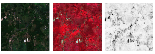
For geospatial AI, remote sensing, change detection, and environmental monitoring
Generate unlimited high-resolution satellite-like imagery with full control over:
Perfect for training models that need rare events (floods, deforestation, illegal activity) without real satellite costs or access restrictions.

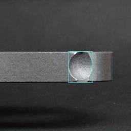
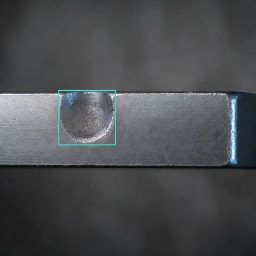
For robust object detection, instance/semantic segmentation, 3D perception
Create photorealistic scenes with arbitrary objects, poses, lighting, occlusions, backgrounds, and camera angles — always with pixel-perfect annotations:
Ideal for robotics, autonomous systems, industrial inspection, retail — especially when real data is scarce, biased, or privacy-sensitive.
For robust OCR, scene text detection/recognition, layout analysis, and VLM fine-tuning
Generate realistic text in two key domains – fully controllable and always perfectly annotated (character-level, word/line bounding boxes, transcription, key-value pairs):
Train models that excel on both clean scanned documents and challenging real-world text without privacy risks or collection hassles.

Want to know more? Contact us and learn how we can help you!
We look forward to hearing from you.
Lichtenbergstr. 8
85748 Garching
Germany
In order to awnser your request the data provided by you through our contact formular will be processed on our server. For more information please refer to our privacy policy
Angaben gem. § 5 TMG
Vypno GmbH
Lichtenbergstraße 8
85748 Garching
Registergericht: Amtsgericht München,
HRB: 251315
Geschäftsführer: Maximilian Jakasovic
Telefon: +49 175 1141726
Email: contact@vypno.com
Our Privacy can be found here
The website of the Vypno GmbH contains information that enables a quick electronic contact to our enterprise, as well as direct communication with us, which also includes a general address of the so-called electronic mail (e-mail address). If a data subject contacts the controller by e-mail or via a contact form, the personal data transmitted by the data subject are automatically stored. Such personal data transmitted on a voluntary basis by a data subject to the data controller are stored for the purpose of processing or contacting the data subject. There is no transfer of this personal data to third parties.
We do not accept any responsibility for or endorse the content of external websites we link to, whether directly or indirectly. The providers of the linked websites are solely responsible for all content presented on their websites and in particular, any damage resulting from the use the information offered on their websites.
Liability Disclaimer: While the content of this website has been put together with great care and reflects our current knowledge, it is provided for information purposes without being legally binding, unless the disclosure of this information is required by law (e.g. the legal information), the privacy policy, terms and conditions or mandatory instructions for consumers) . We reserve the right to modify or delete the content, whether in full or in part, provided this does not affect our existing contractual obligations. All website content is subject to change and non-binding.